The article was originally published on Bellingcat.com
Co-Authored by Taron Hovhannisyan and Vlad Vardanyan, resident analysts at the Orbeli Centre

After the collapse of the Soviet Union, the three former republics of the Caucasus, Armenia, Azerbaijan and Georgia, failed to demarcate and delimit their borders. This failure has resulted in regular incidents across the fringes of each nation’s respective territory. The well-publicized border disputes between Armenia and Azerbaijan are complex in nature, and the two nations have had a prolonged, often violent dispute regarding territorial control in the Artsakh (Nagorno-Karabakh). However, the situation regarding boundaries that lie in between Georgia and Azerbaijan, two friendly nations of the South Caucasus, has also brought about complications with demarcation.
Recently, a dispute in the Babakyar mountains, which includes territory from all three states in the Caucasus, have spurred a number of misrepresentations in the media and condemnations from respective governments. Azerbaijan has strengthened its position on new heights on the peak of the Babakyar mountains, which is situated within Georgian territory. Consequently, Azerbaijani media outlets have reported that strategic heights on the border with Armenia have been taken under their government’s control. In response, the Armenian media have reported that the Armenian Armed Forces took control over territory of around 140 hectares, reportedly done to counteract Azerbaijan’s initial thrust into the Babakyar Mountains. This new area under Azerbaijani control within the mountains held tactical value for Azerbaijan against Armenia up until Armenia’s response neutralising the threat.
Azerbaijan’s Chief of Staff of the State Border Service, Major General Elchin Ibrahimov, mentioned in his statement that Azerbaijan has “advanced on the contact line in several directions and gained a foothold in strategically important heights”. In viewing freely-available satellite imagery on Google Earth, we can see that the Azerbaijani military advance occurred within Georgian territory. As seen below, Azerbaijan’s fortification of their positions has moved northward, across the border into Georgian territory. Azerbaijan took control of this new peak in April 2019, judging from available satellite imagery. While Azerbaijani officials have not been clear about the direction of the positions, some Russian-language media outlets have reported that Georgian territory was encroached upon in the recent strategic moves.

Georgia and Azerbaijan’s academic war over the David Gareji monastery has brought the sacred site under Azerbaijani control, making another border dispute between the neighbors in the south Caucasus. In April 2019, Azerbaijani border guards closed the entrance to the monastery for Georgian monks in response to the Georgian President’s visit to the Azerbaijani side of the complex which falls under the unofficial delimited side of the border of Azerbaijan.
Azerbaijan attests that the demarcation of the borders should pass at the top of the mountain, which includes the whole monastery, and that the uninvited visit by the President of Georgia was the reason for the Azerbaijani response.
The core of the dispute is complex and has led to new tensions between the usually friendly neighbors. Azerbaijan lays claim to the site via a state-sponsored push to advance the idea of Caucasian Albanian descendancy, which has startled Georgia due to the fact that the monastery is firmly part of Christian Georgian heritage and the site serves as a pilgrimage for Georgian Orthodox Christians. This conflict has also led to Azerbaijan backing Georgia into a corner with the most sensitive element in the long-running negotiations — demarcation. With little to no response by Georgia, Azerbaijani strategy has had a foothold in recent times in the Caucasus against both of their neighbors.
Below, a map shows the site of this monastery, along with recent outposts and the demarcation lines.

According to satellite imagery provided by Google Earth and Planet Labs, Azerbaijani units have extended control over a number of positions (noted by red pins) situated within Georgian territory.


It should be noted that in satellite imagery provided by Google Earth, the demarcation line of the borders match the ones from the former USSR General Staff maps. The picture provided below is a piece of the General Staff map (K-38-103) from 1976, showing that Babakyar was a part of the former Georgian SSR, not Azerbaijan. The demarcation on the Google Earth map also corresponds to the Soviet map in the area extending to the Georgian-Azerbaijani Red Bridge border checkpoint.

The Armenian Armed Forces have made some progress towards the top of the Babakyar Mountain as well.

The situation across the Babakyar Heights in March and April 2019 (Planet Labs)
The Babakyar mountain peak in 2009 had an established post, but recent imagery shows the strengthening of new positions and additional advances into Georgian territory.

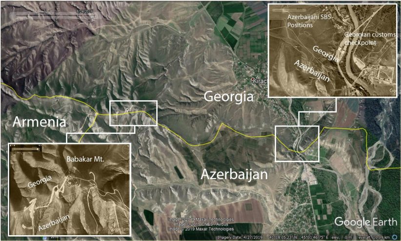
New positions located in the east of Babakyar mountain are de-facto located in the territory of Georgia. A more accurate observation of the aforementioned section of the Georgian-Azerbaijani border indicates that Azerbaijan holds positions not only in the Georgian territory of Babakyar, but also in the area stemming from Babakyar to the Georgian-Azerbaijani Red Bridge border checkpoint.
Moreover, one of the Azerbaijani positions (marked with red pins below) in this zone lies only 380 meters away from the Red Bridge Georgian customs checkpoint, located on a higher hill, on the west side of the checkpoint.

Thus, in the direction of the border with Georgia, starting from the borderline with Armenia to the checkpoint of the Red Bridge, Azerbaijan has taken control over about 200 hectares (two square kilometers) of Georgian territory, holding a potential advantage over the Red Bridge Georgian customs checkpoint or at least threaten it as well as the nearby village of Kirach-Mughanlo.